1890 Map of Redding meets Google Earth

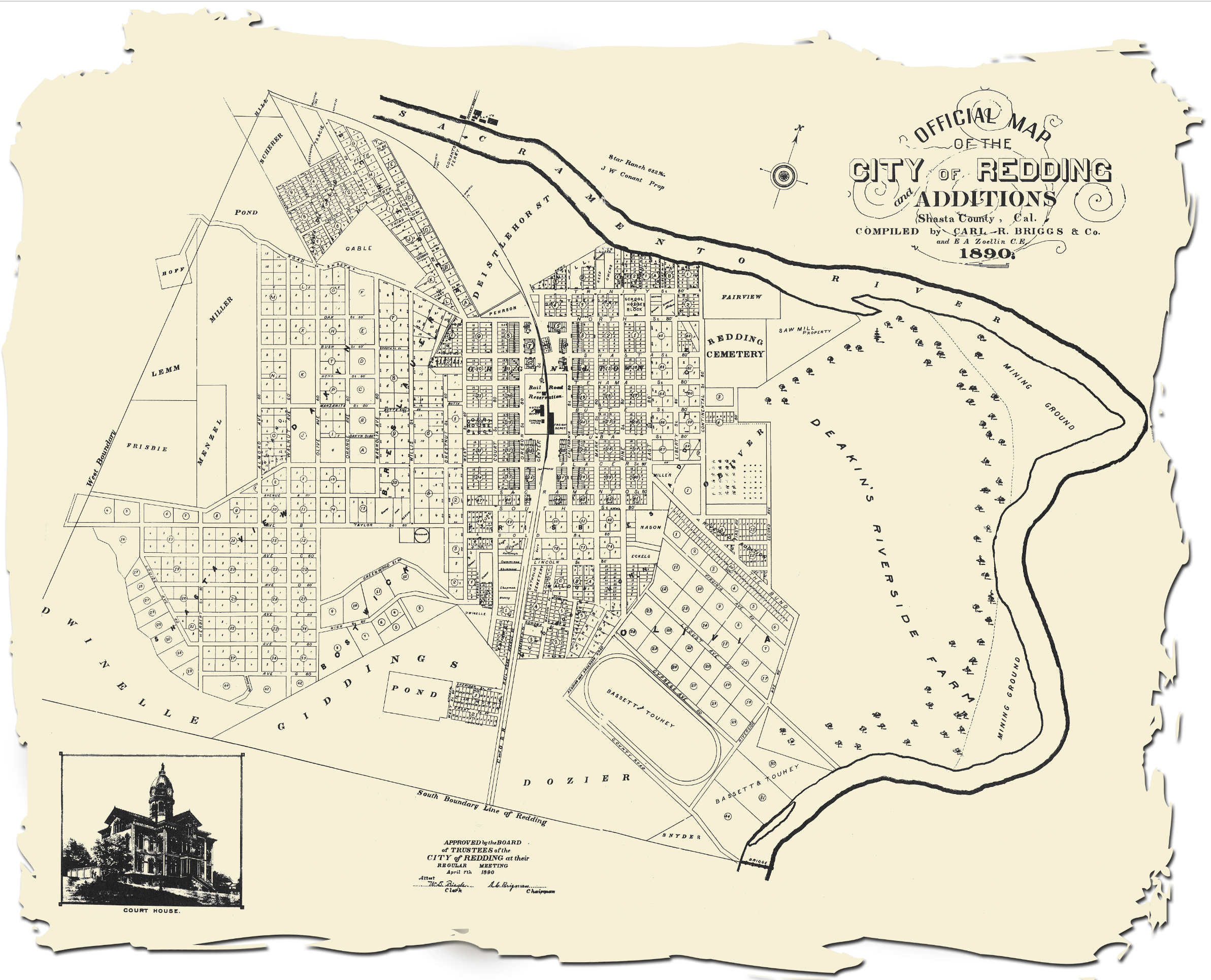
This Map of Redding from 1890 matches up well with satelite imagery borrowed from Google Earth. I did these frames some time ago, but finally got around to animating them.

Click to enlarge

1890-map-stacked-2

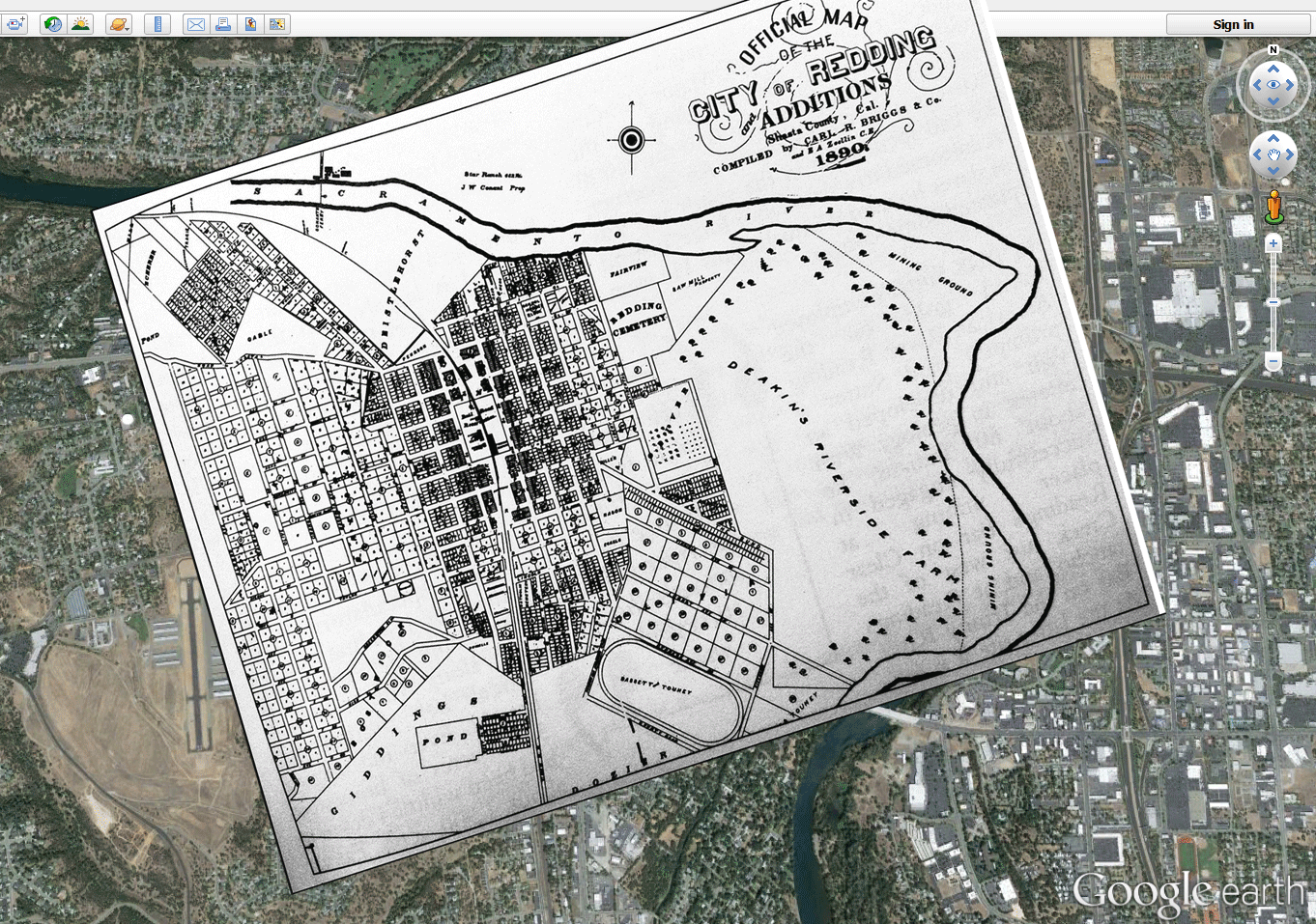
Being a rail town on a river, things still line up very well. Except now you can see the train tracks turn north over the river, since they built Shasta Dam. The Redding Cemetery is easy to see. The sawmill became the Posse Grounds.  Looks like our city hall was once a horse racing track!

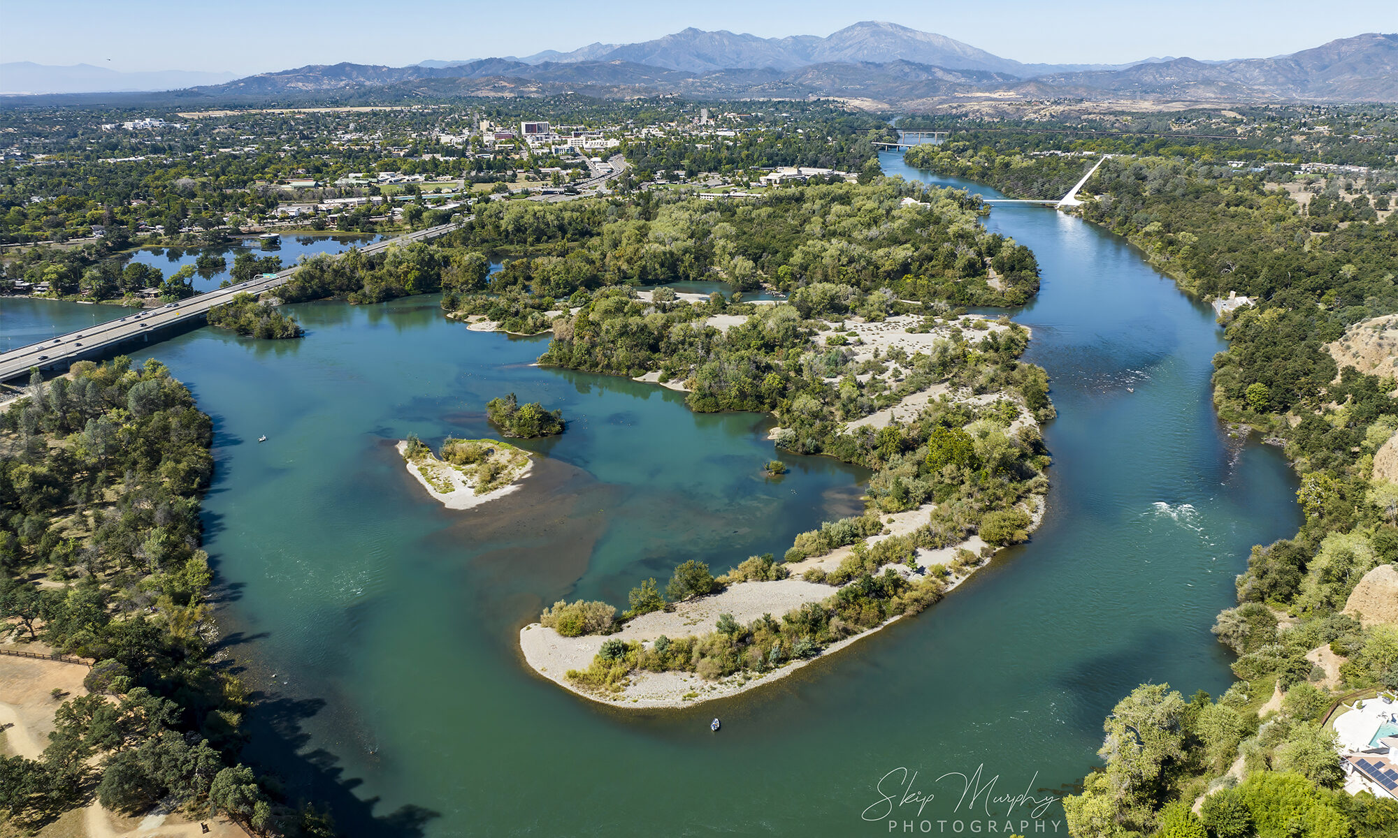
Deakins Riverside Farm became Turtle Bay and The Garden Tract. I wonder if farmer Deakin had any inkling that he had probably the most valuable real estate in Redding’s future. That stretch of river holds so much promise, still.

I love old maps. I don’t recall how I came across this specific one. If you like this sort of thing, check out this 1872 map of Redding overlay I posted in 2011.

 
This version of the 1890 Map of Redding came from the Shasta County Library site. The building is the old courthouse in Redding that no longer exists. You can click this to to enlarge also.
1890-map-of-redding

Bike to the movies in 1940 Redding

While surfing at the Library of Congress website, I came across images of the Cascade Theatre in Redding from 1940.

FSA /8c32000/8c322008c32225a.tif

This available .TIF image is remarkably high resolution for an online photo.

I wondered what it would look like zoomed in. Please do click below to enlarge.

FSA /8c32000/8c322008c32225a.tif
Bikes and their riders going to the movies in Redding in 1940

Hey, remember when you could ride your bike to the movies, and leave it unlocked out front?

I don’t. But evidently, such a scene existed. Lined up to see “Jungle Book” and “Blondies Blessed Event.” (which you can now watch on YouTube)

Closer in yet, a young woman looks right at you. You are a phantom from the future. Click to enlarge.

FSA /8c32000/8c322008c32225a.tif
Evidently Redding folk once dressed somewhat more formally to go to the movies.

It looks like a windy day in Redding, that day in 1940.

The winds of change. Hang on to your hat.

Back then, moviegoers paid a “Defense Tax.

FSA/8a29000/8a296008a29687a.tif
10% Defense Tax for General Admission. 16% for you Students.

Zooming in. The work of Redding Signs.

FSA/8a29000/8a296008a29687a.tif
Redding Signs.

Coincidentally, another “Jungle Book” remake is currently playing in a Redding theater. Seen below here in 2016 at the Cinemark Movies 14, across town from the Cascade.
Junglebook at the Cinemark

Movie admission prices have gone up a bit since 1940.

A discount for seniors now, instead of students. But at least your “Defense Tax” is built in.

Historic Redding Theater on California Street

Facebook friend Lee Riggs posts to a group Northern California History. I always find his posts fascinating. He recently posted this image of the Redding Theater marquee on California Street in Redding, from the famous Eastman collection.

Historic Redding Theater California Street
I did some Photoshop cleaning, and enlarged it a bit. I like how it turned out. Click to expand.

Historic Market St Redding

This story of life in Redding years ago appeared in the comments section of the Facebook post. Curating it here, since it adds detail that helps paint the picture of daily life here years ago.

“JOE Cabitto was washing dishes in Jaegel’s Cafe when the two prospectors came in lugging a gunny sack holding a gleaming 370 ounce gold nugget. The miners had found the nugget in Motion Creek, which joins the Sacramento River just below Shasta Dam. At the time, Shasta Dam was still 30 years in the future, Cabitto was a strapping young fellow and Redding had about 4,000 residents who swatted mosquitoes and shivered with malaria, even in the blistering summer heat. Jaegel’s, where Cabitto washed dishes and waited table, was a no frills cafe offering hearty roast beef dinners for 35 cents. Jaegel’s location eventually would be swallowed up by The Mall in downtown Redding, and Oser’s women’s wear store would replace the cafe. Nobody even dreamed of a mall.

Cabitto was “pearl diving,” or washing dishes, in Jaegel’s Cafe. Across Market Street, in those days, was Bags McConnell’s pool hall, where a Western Union “boy” stood on a stool and read a blow by blow telegraph version after each round in the 1927 Dempsey Tunney fight. Cabitto won $800 on that fight, the outcome of which still stirs bitter arguments because of the “long count” the referee gave Tunney after Dempsey knocked him down.

Jaegels was the favorite restaurant not only for the men who worked in town, but also for the farmers and miners who came to town on business. It was on the west side of Market Street just north of the Yuba Street intersection. All the cooking was done behind the counter on a wood stove. I had to go out into the alley in the back to cool off. There were a couple of big ceiling fans but all they did was keep the flies off the counter. The meals were served at the counter except for a couple of tables at the back where the few women who came in were served. It was my job to serve them. We called the tables the “Blue Room” and I really hated waiting on those women, especially when they were drinking. Dinners were thirty five cents and were served from 11:30 AM to 3:00 PM. That thirty five cent dinner included what they had cooked that particular day—roast beef, roast pork, beef stew, or on Thursday we had corned beef and cabbage, plus three pieces of bread with butter, potatoes, coffee or milk. After 3:00 PM the meals were served short order, mostly steak. A rib steak cost forty cents, a T bone sixty five cents. They were thick too. Fridays we had fish—halibut and sanddabs from Seattle, or fresh eastern oysters which came in cans packed in ice. Jaegel’s was the only place in town that served 10 cent coffee. All the other restaurants sold it for a nickel. The reason was we had to get rid of the morning coffee drinkers so there’d be room to start serving dinners at 11:00 to the regular customers. Some of the other people who worked there were: Ed Gibson and August Jacobi, the bartenders, Bob Gibson and Barnett, the cooks, Bill Rester, the waiter. George Lapp was the owner. His mother had been a Jaegel. The pay was $85.00 a month and board for seven days a week, eleven hours a day and no vacation. So we figured the more we ate the more we got paid. I went from a modest ] 65 pounds to 240 pounds. During the Depression we had to take a cut in pay, down to $65.00 a month, but they didn’t cut the prices for the meals.”


Again, this is from Lee Riggs. Thanks for sharing.

Antlers Bridge replacement in Lakehead is a colossal structure

I don’t think these photos quite capture the scale of this mammoth construction project began in 2009, and located about 20 miles north of Redding. I don’t think I’ve ever come across a construction project this big before, hence why I’ve just had to take a photo of it. I was just amazed by the enormity of it, and I think it’s fair to say that I wouldn’t want to be a construction worker at this moment in time. Imagine the stress and the constant pressure they must be under to get it done? I just hope that their construction manager has the relevant qualifications to pull it off because it must be a very tough job. In fact, I may decide to have a look at sites like Raken just to see if I could potentially become a construction manager if I wanted to. Having the relevant skills would be important, but knowing how to manage a team and a project like this is even more essential, especially if you don’t want it dragging on for this amount of time.

Anyway, I just thought you’d like to see what I saw the other day, as I don’t think my eyes can still fathom it. Also, my shots are blurry since I was just waving my camera around while riding up Interstate 5. You can’t really see it very well while whizzing by at speed, so I thought I’d try to capture it on camera.

Below, you can see a worker in orange on a lift at lower right, for scale. These folks are working a hundred feet (a total guess) in the air. Click to slightly enlarge.
Bridge4sm

Bridge2sm

And then these two completely separate structures have to perfectly meet in the air. Impressive work!

Bridge6

Below, you can see the giant fish bas-relief in concrete. I suppose it will be only visible from the lake.

Bridge3sm

Here’s a better look at the artwork, an image taken from the Cal Trans Antlers Bridge Replacement Project website where you can get a much better view of the work.Bridge Antler Fish

The Cal Trans website also had this interesting historical image of the original Antlers bridge construction from 1941.
Bridge Antler 1941The sparse vegetation seen in historical photos is always striking to me. The Northstate was much more fire-safe back in the day.

Mabel and her bike

Columnist/Blogger Marc Beauchamp posted this interesting image of his maternal grandmother Mabel Frisbie and her bike in Redding circa 1910 in anticipation of a presentation about local bicycling.
Mabel Frisbie1I wondered if I could clean it up. I’m not sure I added any clarity to the subject, but here’s what I ended up with. It was fun work, and I learned a few things.
Mabel Frisbie4The “Women on Wheels” presentation is happening Saturday February 15, at the Shasta County Downtown College Building across the promenade from the Historical Society. It starts at 1:30 pm, and will feature Anne Thomas of Shasta Living Streets. I hope to be there if I’m not working. Thanks much to Marc Beauchamp for sharing the image.

Camden House offers a glimpse of Shasta history

Merry Christmas to you and yours on this holiday eve in 2013.
Here’s the historic Camden House just west of Whiskeytown Lake with some holiday decor.
Tower House Christmas 2013-2Tower House Christmas 2013
There are historic tours listed at the Whiskeytown Ranger led tours page. This from their web site

“Walk In Time (2 hours)

Wednesday and Saturday at 3:00 pm
Discover how pioneers/prospectors Charles Camden and Levi Tower reshaped the landscape to create a home for their families and an “oasis” for many travelers during and after the California Gold Rush. After a tour of the Camden house, built in 1852, enjoy a leisurely stroll through the area, then try your hand at finding gold the old-fashioned way-with a gold pan in the creek! Please bring a bottle of water and extra clothing if you choose to get wet. Meet the ranger at the Tower House Historic District parking lot in front of the bulletin board kiosk.”
Tower Camden House bridge

The Afterthought Mine in Ingot, east of Redding

If you drive out past Bella Vista on Highway 299 going east, it starts to follow Cow Creek in a canyon. Right about there, is Ingot, former home of the Afterthought Mine. It used to be easy to spot when the big smelter ruins were mostly intact, but they have been dismantled over the years. We have a painting of how it looked in 1973, done by a family friend Mrs. Esterdahl.
The Afterthought Mine SmelterOld timers will probably recognize it. At some point I acquired a $500 bond issued for the mine from 1909. It pays an annual dividend of 6%. Payable in gold coins, of course, maturing in 1913. Kind of fun to think about that. Knowing something of local mining realities, I wonder if the bearer was ever paid at all. Just an afterthought now.
Ingot mine bond


View Larger Map
We have an old Shasta County mine listed for sale, if you’ve a mind to try your hand. It’s the Jealous Quartz Mine, southwest of Shasta Dam. Let us know if you’d like to buy it!

1872 Redding map overlayed to present day Google Map

Dottie Smith is a local historian I admire very much. A few days ago, she posted a map of Redding from 1872 at her blog:

http://blogs.redding.com/dsmith/archives/2011/05/when-and-why-re.html

Redding Ca in 1872

I find old maps fascinating. I wondered what it would look like overlaying a present day photographic image of Redding from Google Maps. Turns out, it lined up very well. You can click these images to enlarge slightly.
Map of Redding CA
Redding California Shasta County
Redding in 1872
Present Day Redding CA
With imaging software you can scroll smoothly through, back and forth from 1872 to 2011. 139 years. Interesting to note the transportation hub of the day remains exactly in place in the form of the railroad station and the RABA/Greyhound terminal. Much has changed however. Particularly our sense of scale. There were hundreds more parcels on the densely populated 1872 map.
Thanks Dottie! And thanks Google! You both provide daily insights to our sense of place.

May Day images in Redding 2011

This season has proven to be an extraordinary Spring, with an abundance of wildflowers, water in creeks, and birds in the trees. It was a wet end to Winter, but a magic May Day ensues.
Springtime in redding CASacramento River and Mt Lassen in Redding CA
Popped my head over the bridge, and spotted these two enjoying the sun by the river.
Girls enjoy the River near Redding's trestle
That reminded me of this image from Redding long ago.
Redding Ca at the Sacramento River

Boot Hill graveyard…

…became the Buckeye Pioneer Cemetery. A rainy day seems appropriate for a few images.
Buckeye Pioneer Cemetery in Redding CAThere’s only this one marker. The names date from the late 1800s. The entire site is just a parcel amongst homes on Irish Road just north of Redding.
Buckeye Pioneer Cemetery in Redding CABuckeye Pioneer Cemetery in Redding CAHardscrabble lives came to rest here on Boot Hill. Ghosts in the live oaks…